An 800-meter rip current: Reading the water at Langstrand
I was driving on the gorgeous Namib coast, between the golden dunes and the blue sea. The strong wind from the desert was piling sand onto the road and I wondered how quickly those dunes move.
For an answer, I looked at historical satellite imagery 15 years back and compared it to today. As is becoming customary to my blogging approach, the first idea never quite pans out as I would hope. Some deserts migrate 80 meters a year. Langstrand dunes apparently not.
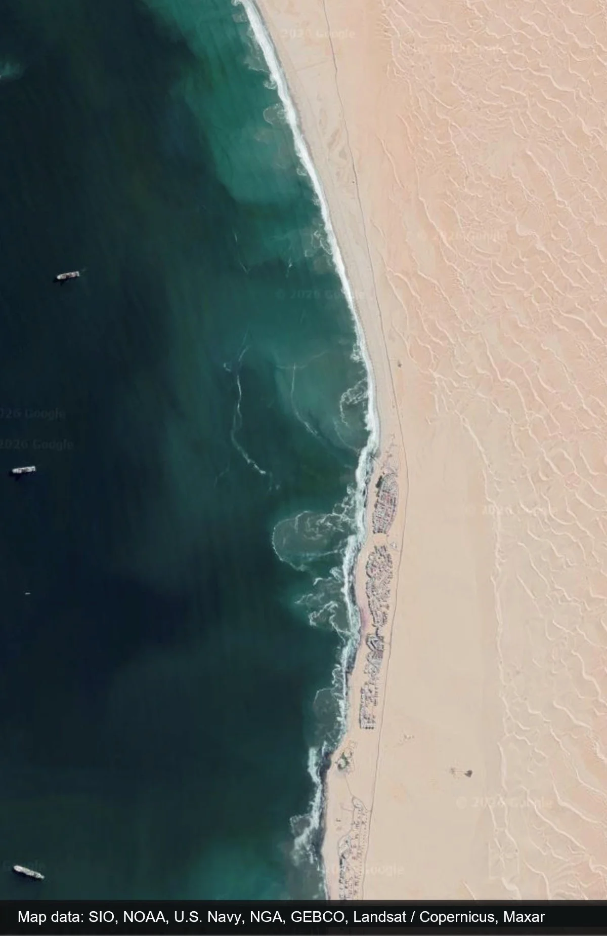
Fortunately, trying to find something often leads to secondary findings. While browsing the historical imagery, I noticed the below water feature on the beach. It’s big.
The accidental finding on water while looking at the dunes on the right.
1. A powerful rip current
The feature is over 800 meters long offshore and considerably mixes up the water beyond what typical surf-zone turbulence would suggest. There is a break in the line of buildings on the shore possibly creating a local wind tunnel, but a wind-jet caused feature would be sharper with linear streaks. The plume of sediment-rich water with a clear directional pattern is the signature of a large rip current.
I’m familiar with rip current formation and won’t go deep into the explanation here, but I’ll say the text book “hole in the sandbar” formation is not always clearly evident when looking at rip currents on oceanic beaches.
The key requirement is that the beach and ocean floor near the beach are not uniformly flat, so there are subtle or distinct channels leading in and out of the beach. When waves push water toward the shore faster than it can disperse laterally along the beach. The excess water returns seaward, and the backflow concentrates on the channels.
Below is a text-book case example from the Portuguese coast with calm seas and turbulent rip current conditions that I was lucky to find.
Text book case beach in Portugal.
Text book case beach in Portugal with clear rip and a turbulent cell.
2. Why it forms in Langstrand
There are dozens of infamous rip current spots around the world. After reviewing imagery in around 5 famous spots in the US, Europe and Brazil, the rips were visible but rarely if ever extended hundreds of meters. This one in Langstrand shows up in the images repeatedly.
This could be a lucky coincidence in imaging dates, but the number of findings suggests there is something unique at play at Langstrand. Moreover, Namib coast is dotted with dozens of other powerful rip currents evident in the imagery. Below, a zoomed out view of our target area shows the turbulent nature of the coast.
Wider view reveals a turbulentic coast.
I have stood on that Langstrand beach but can’t remember any warnings from the hotel about rip currents. Of course, the cold 14°C degree water temperatures discourage most swimmers and it is not exactly a beach destination.
The Namibian Port Authority’s bathymetry below reveals a U-shaped shallow that aligns well but not perfectly with our feature. The wider context however is that the bathymetry contours follow the curvature of the shore, which explains even more of the formation. A close look at the beach also reveals “rocky pockets” that trap water near the origins of the jet.
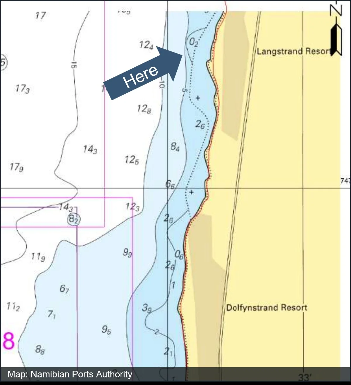
Our study area in the bathymetry map.
Incoming swell floods the shallow basin. The accumulated water then escapes along its flanks, curving around it and focusing into a persistent seaward jet. This formation theory is marked into the satellite photo below.
Calmer conditions but clear visible jets.
Turbulent conditions with clear jets originating at the same locations.
Frequent formation is supported by persistent southerly wind conditions, accompanied by the cold Northward-flowing Benguela current and long-period Atlantic swell. The origins of the wind regime is visited in a dedicated post about Lüderitz in Namibia, a few hundred kilometers south of Langstrand.
3. Conclusion
Oceanic beaches deserve extra respect. What I enjoyed most about today’s process was the cascading journey. Failure to find moving dunes shifted to an oceanic feature. That led to bathymetry and ultimately an emerging curiosity regarding how the Benguelan current creates the Namib coast wind regime.
Keep an open mind in nature, you’ll never know what you’ll find.
See you,
Orbital Vantage