Russian military bases in SAR: X marks the spot
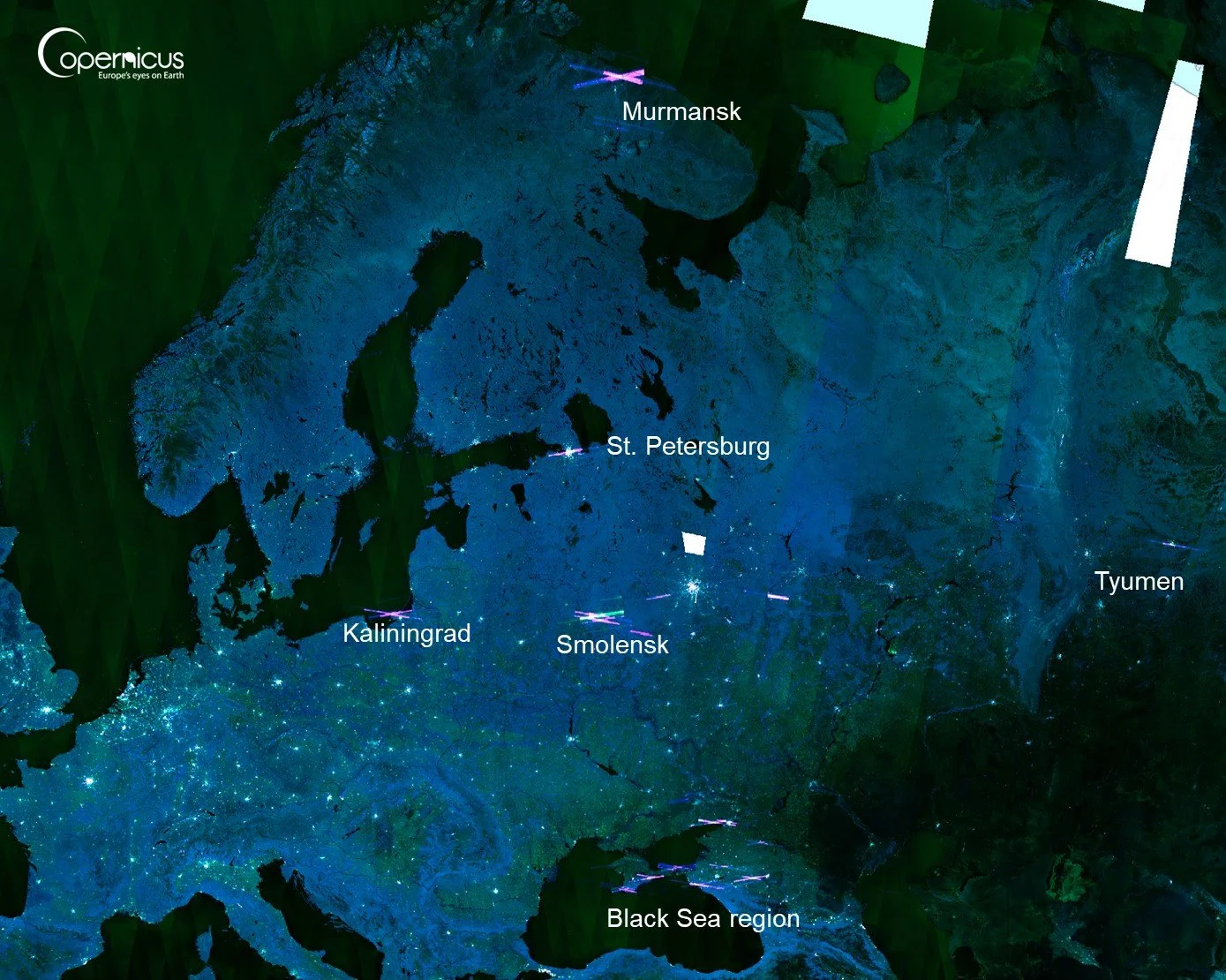
SAR “Urban” Mosaic in December 2025, showing purple returns in Russia. Bright spots are cities.
Open almost any SAR image over Russia, especially near Ukraine, and bright X-shaped radar artefacts appear like in the image above. It’s too consistent and specific to be random so today, we explore the reason.
This was actually one of the first accidental findings for Orbital Vantage when only a few posts were published. It wasn’t pursued at the time as jumping straight into a topic related to Russia-Ukraine war was not where we wanted to establish identity. Also, thinking of possible theories took more than 15 minutes.
1. What we see
Sentinel-1 is a radar satellite. It sends out microwave pulses and observes the echoes that return from Earth, seeing through cloud and not relying on optical bands. It is also very sensitive.
Below is a mosaic view over Black Sea in December 2025. There are long, purple streaks creating X-marks in various locations. These X’s for the most part stay in shape no matter which month’s mosaic is viewed and typically also appear on daily scenes.
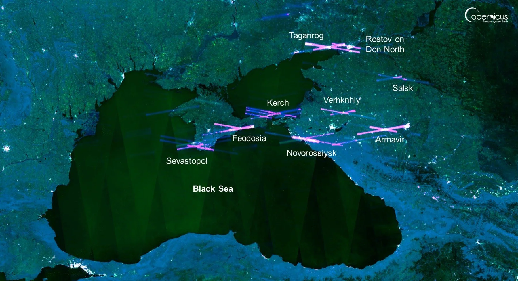
Clusters of SAR anomalies in Southern Russia, in the active conflict region.
Zooming out, similar patterns appear around other Russian strategic areas like Kaliningrad, Murmansk and Smolensk. That is our first clue.
Looking at optical imagery, I wasn’t surprised by the findings. Around the Black Sea, the strongest patterns appear near cities with notable military bases: Sevastopol, Kerch, Feodosia, Novorossiysk, Taganrog, Rostov-on-Don and other nodes in southern Russia (see below a few examples). In Taganrog, the image shows 18 aircraft that look like IL-76 military cargo plane, and 13 An-12 turboprops, though some appear to have been parked for an extended time.
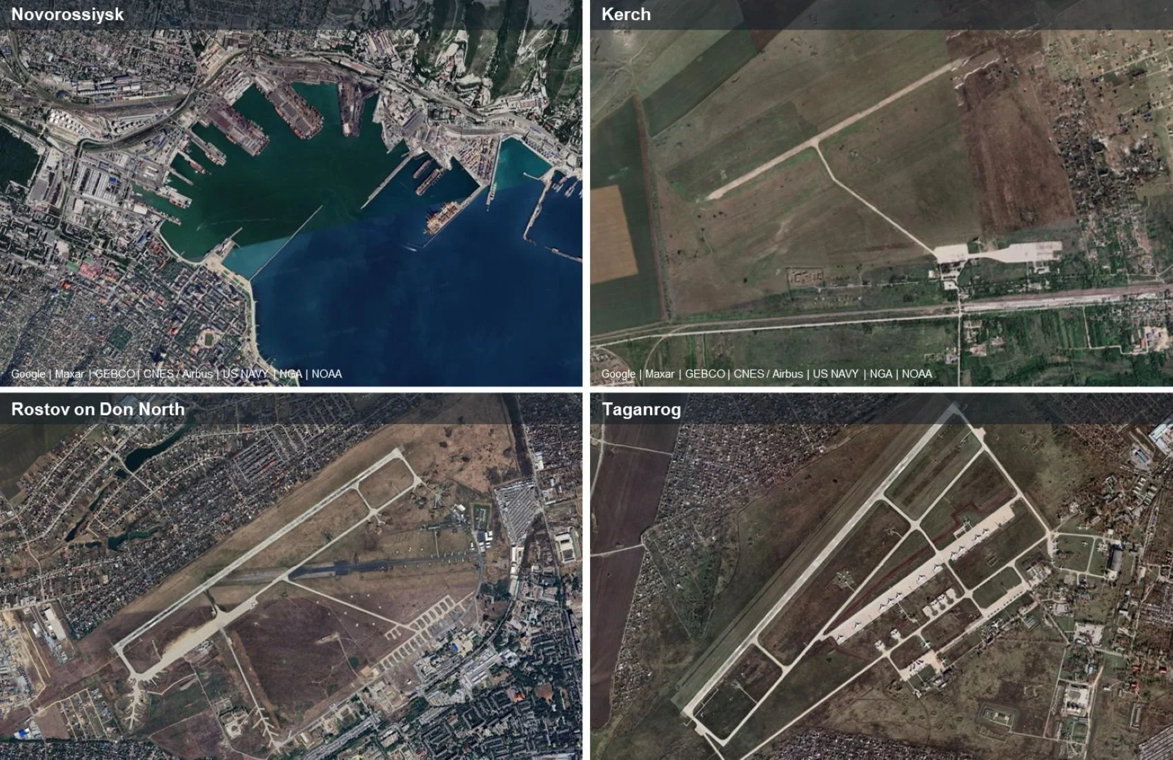
Optical views on the locations near the SAR X’s. Kerch airport looks modest in the image, but more recent Copernicus/Sentinel imagery shows active construction.
2. Why is this? Three theories
There are a few possible explanations we considered. Seeing that the streaks can appear just as powerful in daily images as in mosaics, we can immediately eliminate mosaic-processing artefacts as the primary explanation. Similar returns are rare elsewhere in the world, though I did pick up a few in China.
Theory 1: Ordinary radar reflections from military infrastructure
This was the most intuitive explanation.
Military bases contain metal buildings, aircraft shelters, ships, cranes, fences, radar masts, hardened structures and other objects that can strongly reflect radar energy. SAR loves geometry and this is why antennas, ships and ports create similar if magnitudes smaller SAR X’s all over the world.
So perhaps the satellite is simply seeing military infrastructure. But this explanation breaks down quickly: Military infrastructure is not unique to Russia. Many countries have naval bases, airbases, hangars and radar domes that look very similar. But these X’s predominantly appear over Russia.
This is not a plausible theory.
Theory 2: Deliberate jamming of the C-band
This would be the dramatic explanation. We know SAR is widely relied on for military intelligence. Perhaps Russian military systems are deliberately jamming SAR-platforms?
It is possible in principle. A sufficiently powerful transmitter in the C-band frequency range can contaminate the satellite’s receiver and the result looks like image corruption. This is different to Russia’s GPS jamming, which operates on significantly lower frequencies, and should not be picked up by SAR but could in theory also interfere with the signal.
See below SAR image of Taganrog air base on May 2nd 2026. If Russia wanted to hide the air base and its current assets from SAR, they succeeded.
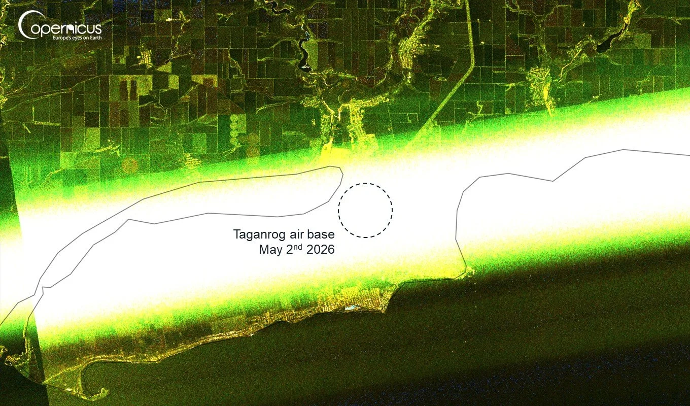
SAR view of Taganrog air base completely hidden by the SAR anomaly.
But there are also counter-arguments against this theory. We would expect more continuous “jamming” and this is not always evident browsing daily images. Also, in some locations the “X” doesn’t really sit on top of the military base but somewhat off like in Sevastopol. Finally, a blanket, area-denial jamming might show up more broadly rather than as a specific X that in many cases still leaves much of the key military area visible.
Still, Electronic Warfare -related emissions remain a very plausible explanation, if not “Confirmed” in Mythbuster terms. At least not with the intel I have available.
Theory 3: Incidental radio-frequency interference from military radars
The final theory is similar to 2 in its formation mechanism, but instead of jamming, could the X’s be by-products of continuous air defense radar surveillance?
Sentinel-1 SAR (our images) operates on C-band at 5.4GHz. Weather Radars operate on similar bands, but the world is full of weather radars and we only see these X’s near Russian military bases. So that’s not it.
Russia’s key military air defense radars reportedly operate on lower S-band (2-4Ghz) for long-range tracking and X-band as high as 8-12Ghz for precise target tracking. They emit a lot of radar energy. While these operate at different frequency bands to SAR and shouldn’t in theory interfere with it, there are a few mechanism (e.g. radar band-leakage) that are possible.
I tried finding military radar platforms in the images, but the image resolution and my patience was not enough to find them, but came closest to Sevastopol below. See first the SAR return, and further below optical view of the location where the X is roughly centered.
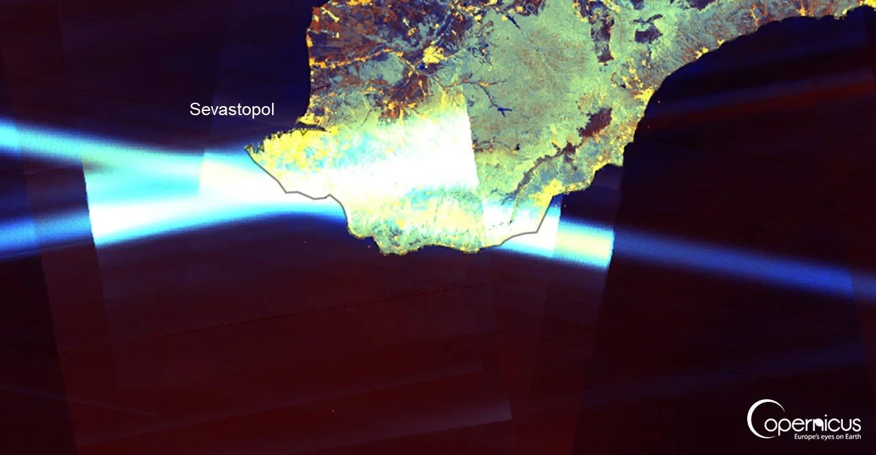
SAR view over Sevastopol with a major naval base. The X is centered on an area away from the heart of the military area, however.
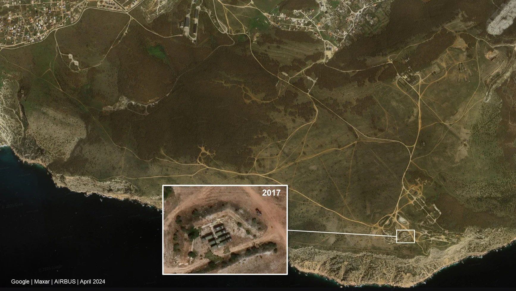
Closer view of the area where the X roughly lands reveals a high-point in terrain, with military roads, old artillery installations and past-presence of military vehicles.
The location above is suitable for a typical air-radar: A high-elevation spot with 360-view of the area, though not exactly a good hiding spot. There are also military vehicles and roads evident at the location in the imagery.
This air defense radar explanation would make sense too. The military locations are hardly a secret and under continuous air threat, so keeping radars “on” gives nothing away while offering protection. But why are there virtually no similar X’s in Europe, US, India, Pakistan, Iran, Israel with continuously active air defense radars? Could be tighter radar band control or less intensive monitoring.
All of this now goes beyond my knowledge, so we’ll stop here and conclude that the air defense radar interference theory is also possible.
3. Working hypothesis
The resulting hypothesis is that these artifacts are caused by radio-frequency interference from powerful Russian military radar systems or incidental/deliberate jamming of the C-band to hide from SAR satellites.
What is clear in either case, is that Russia appears to have a dense, persistent, layered air-defence environment around the kinds of places where these artifacts show up: Naval bases, airbases, and other strategic military locations.
4. Conclusion: Why it matters
First, this has near-zero direct military value. It does not really reveal that Sevastopol, Kerch, Novorossiysk, Rostov-on-Don or Kaliningrad are militarily important. Because if that is news, your military intelligence needs a bit of work.
It also does not provide targeting-grade information as the X-marking the spot is the size of a small country, and does not tell us exactly what emitter is operating, what mode it is using, or what its readiness level is. At most, it hints that powerful emitters were active at certain times and places.
But for us as an Earth observation curiosity, it was definitely worth a closer look. It is also a reminder that satellites are instruments, not just cameras. They can be blinded and fooled, and can accidentally detect things they were not designed to study, and this insight finally does have some military value.
See you,
Orbital Vantage